
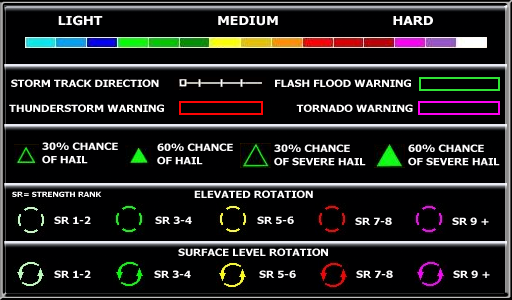
[10/10]

The above image was produced by GRLevel3 software using NEXRAD Radar data from station KDVN.

Navigation
External Links
Alerts
USA Extremes
High Temperature
114°F at La Grange Caa Airport, GA
Low Temperature
27°F at Victorville Southern California Intl Ap, CA
High Precipatation
10.00in at Hampton Roads Executive Airport, VA
Data courtesy of NWS-CPC
Affiliations


Paypal
THANK YOU FOR THE MAJOR DONATIONS RECIEVED FROM THE FOLLOWING 3 LOCAL BUSINESSES


[10/10]
The above image was produced by GRLevel3 software using NEXRAD Radar data from station KDVN.