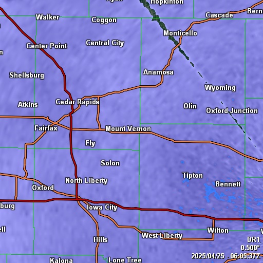
No Warnings, Watches, or Advisories
Radar
GR3 Radar Satellite Images (Courtesy of NOAA)
Updated: @ 24-Apr-2025 7:30pm - next update at 6:00pm  
Summary / Temperature Wind Rain Outlook
Dusk Dusk
Currently: 68.1°F, Max: 80.2°F, Min: 57.3°F 68.1°F
Colder 7.2°F than last hour.

---

Feels like: 74°F

24-hr difference
-3.1°FColder 3.1°F than yesterday at this time.
  Today Yesterday
High: 80.2°F
2:34pm
76°F
4:47pm
Low: 57.3°F
6:11am
55.5°F
5:11am
 Wind from NNW NNW
7
Gust:
8 mph
2 Bft - Gentle Breeze
Today: 21 mph 9:17am
Gust Month: 47.0 mph April 2
Rain Today: 0 in
Rain Rate (/hr): 0 in
Rain Yesterday: 0.3 in
Storm Rain: 0 in
This Month: 2.71 in
Season Total: 5.9 in
8 rain days in April.
Friday

Friday: Showers And Thunderstorms
Showers And T-Storms
Humidity & Barometer Almanac Moon
Humidity: 69 % Increased 20.0% since last hour.
Dew Point: 57.5°F Increased 2.8°F since last hour.
Barometer: 30.066 inHg Falling 0.01  inHg/hr
Baro Trend: Steady
Sunrise: 6:08am
Sunset: 7:56pm
Moonrise: 4:51am
Moonset: 5:29pm
Waning Crescent
Waning Crescent, Moon at 26 days in cycle
11%
Illuminated
UV Index Solar Radiation
   0.0    None
High: 3.7 @ 2:48pm
16 W/m2 (27 %)
High: 942 @  1:05pm
 NWS Weather Forecast  - Outlook: Tonight & Friday
Tonight

Tonight: Slight Chance Showers And Thunderstorms
Slight Chance Showers And T-Storms

Lo 51 °F
NWS forecast: Isolated rain showers before 7pm, then a slight chance of showers and thunderstorms between 8pm and 1am, then showers and thunderstorms. Mostly cloudy. Low around 51, with temperatures rising to around 55 overnight. East wind 5 to 10 mph. Chance of precipitation is 90%.
Davis VP+ forecast: Partly cloudy with little temp change.
 
Friday

Friday: Showers And Thunderstorms
Showers And T-Storms

Hi 59 °F
NWS forecast: Showers and thunderstorms before 1pm. Mostly cloudy. High near 59, with temperatures falling to around 57 in the afternoon. Northeast wind 10 to 15 mph, with gusts as high as 25 mph. Chance of precipitation is 80%.

Windy.com Wind Map